Seventy-eight percent of disasters recorded in the United States each year are weather-related. One of the most prominent forms of severe weather disasters encountered here, and around the world (under different names) are hurricanes. Hurricanes derive their name from the Mayan storm god Hurakan, who in myth caused windblown destruction and chaos. It is no surprise, then, that hurricanes can be challenging for public safety professionals, not just because of the destruction that can happen during them, but also for the havoc they wreak afterward. An emergency manager’s ability to analyze and interpret weather data before and during a hurricane is essential to protecting their community – but many safety management personnel didn’t train as meteorologists.
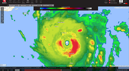
Advanced weather technology like Baron Threat Net makes it easier to predict, plan and prepare for hurricane events, so anyone with any training can help keep their community safe. This article provides a look at some of the most common dangers hurricanes can create for communities, and insight into how Baron Threat Net can help personnel get ahead of even the most challenging weather conditions.
Introduction to hurricanes
How do hurricanes form? Hurricanes (also known as tropical cyclones) are like engines that require warm, moist air as fuel. They form only in tropical regions where the ocean is at least 80 degrees F for at least the top 50 meters (about 165 feet) below the surface. Another required ingredient for the formation of a tropical cyclone is wind. In the case of cyclones that form in the Atlantic Ocean, the wind blowing westward across the Atlantic from Africa provides the necessary ingredient. As the wind passes over the ocean's surface, water evaporates and rises. As it rises, the water vapor cools, and condenses back into large water droplets, forming large cumulonimbus clouds. These clouds are just the begin
The 4 stages of tropical storms
Meteorologists have divided the development of a hurricane into four stages: Tropical disturbance, tropical depression, tropical storm, and full-fledged Hurricane. Once the aforementioned cumulonimbus clouds have formed in warm enough water, a tropical disturbance is possible. If the evaporation and condensation in the system continue, building the cloud columns higher and larger, a pattern develops, with the wind circulating around a center (like water going down a drain). As the moving column of air encounters more clouds, it becomes a cluster of thunderstorm clouds, called a tropical disturbance.
As the thunderstorm grows higher and larger, the air at the top of the cloud column cools and becomes unstable. As the heat energy is released from the cooling water vapor, the air at the top of the clouds becomes warmer, making the air pressure higher and causing winds to move outward away from the high-pressure area. Over time, winds in the storm cloud column spin faster and faster, whipping around in a circular motion. When the winds reach between 25 and 38 mph, the storm is called a tropical depression.
When the wind speeds in the storm reach 39 mph, the tropical depression becomes a tropical storm. This is also when the storm gets a name. Wind direction is counterclockwise (west to east) in the northern hemisphere and clockwise (east to west) in the southern hemisphere.
When the wind speeds in a storm reach 74 mph, the storm is officially a tropical cyclone, otherwise known as a hurricane. These storms are at least 50,000 feet high and around 125 miles across. The eye is around 5 to 30 miles wide. The trade winds (which blow from east to west) push hurricanes toward the west—toward the Caribbean, the Gulf of Mexico, or the southeastern coast of the U.S. The winds and the low air pressure also cause a huge mound of ocean water to pile up near the eye of the tropical cyclone, which can cause monster storm surges when all this water reaches land. Hurricanes usually weaken when they hit land, because they are no longer being fed by the energy from the warm ocean waters. However, they often move far inland, resulting in flooding and wind damage before they die out completely.
The dangers of hurricanes
Hurricanes are massive storm systems that present a variety of challenges and dangers to those in their path. High winds are present in all hurricanes and can cause catastrophic damage. In fact, the intensity of hurricanes is measured by their wind speed (a system which we will cover later). Lightning is also present, as it is in most storm systems. But these threats, though important, are not unique to hurricanes. The main unique danger hurricanes bring to the table is storm surge, which, in conjunction with heavy rain, can cause dangerous flooding.
Storm surge
Surprisingly, although winds are perhaps the most commonly known threat of hurricanes, hurricane-fueled coastal flooding (created by storm surge, waves and tides) is actually the most significant threat to life and property along the coastline during one of these storms. The height of the storm surge (the bulge of water that crashes into the coastline during a storm) is determined by the difference between the height of the storm tide and the predicted astronomical tide. This wall of water is driven ashore by wind and the inverse barometric effect of low atmospheric pressure, and is influenced by waves, tides, and bathymetric and topographic surfaces. The likelihood and impact of the storm surge and coastal flooding depends the intensity of the hurricane, its size, translational speed, angle of approach to the coast, landfall location, and the bottom slope at that location.
Inland flooding
As hurricanes weaken, they transition to tropical storms and move inland. However, the impact of heavy rain bands and still strong winds can still adversely affect the safety and property of citizens of inland communities. Flooding, infrastructure damage, falling trees, and downed power lines are just a few of the potential hazards. Inland flooding can be a major threat to communities hundreds of miles from the coast as intense rain falls from these huge tropical air masses. With more than 60% of the U.S. population living in coastal states, hurricane flooding can pose a severe threat. Over half of all flood-related drownings occur when a vehicle is driven into hazardous flood water. The next highest percentage of flood-related deaths happen when people walk into or near flood waters. It takes as little as six inches of water to sweep a person off their feet. A small car can be swept downstream in about a foot of rushing water and most any vehicle can be swept away in just two feet of water.
There are two kinds of important official warnings to know when it comes to flooding during hurricanes. Flash Flood Warnings are issued when a flash flood is imminent or occurring. People in flood prone areas should move immediately to high ground. A flash flood is a sudden violent flood that can happen in just a few minutes or may take hours. It is also possible to experience a flash flood in areas not actually receiving rain, as an area can be affected by water flowing from heavy rains in nearby communities. Flood Warnings are less specific. They are issued when a dangerous weather event is happening and flooding is imminent or occurring.
Forecasting and tracking of hurricanes
We now have covered what ingredients make a tropical storm form, how those ingredients can intensify into a full hurricane, and the dangers that a hurricane creates. Luckily, hurricanes form relatively slowly and often far out in open ocean water. This makes forecasting and tracking vital to properly dealing with hurricanes. The first step of hurricane forecasting is knowing what constitutes hurricane season.
Hurricane season
The North Atlantic hurricane season officially runs from June 1 through November 30; however, tropical storms and hurricanes have the ability to form at any time as long as the conditions are right. The peak timeframe for North Atlantic hurricanes lies between August and October when the water is warmest, the wind shear is smallest, and the easterly waves are most vigorous. As a result, the hurricanes that have formed during this window include: 90% of the 10 deadliest hurricanes, 97% of Category 5 hurricanes, and 100% of the costliest U.S. hurricanes. In addition, the five most intense hurricanes have made landfall with a 17-day period spanning August 17 to September 2.
Tracking and forecasting
To determine the track and intensity of a hurricane, forecasters gather data regarding atmospheric and ocean conditions. Much of this data can be gathered using satellites, but data also needs to be gathered via air. That’s where the Hurricane Hunters and their SC-130J Super Hercules aircraft deliver. This crew of five, which includes a pilot, copilot, navigator, flight meteorologist and weather reconnaissance loadmaster, gathers data regarding wind, pressure, temperature and humidity. Data is gathered throughout the entire flight including from the eye, which presents a host of dangerous updrafts and downdrafts within 100 feet of one another. Horizontal wind speeds can also shift up to 100mph in a few seconds.
Once forecasters collect data from a storm, if it is a full hurricane, they categorize it based on the Saffir-Simpson Hurricane Wind Scale. This scale is a 1 to 5 rating based on a hurricane's sustained wind speed. This scale helps estimate potential property damage and also provides critical data that helps communities determine where and when to evacuate affected communities, appropriate evacuation routes, and more. Hurricanes that are Category 3 or higher are designated major hurricanes based on their ability to decimate property and the potential for significant loss of lives. Category 1 and 2 storms are still quite dangerous and safety measures should be taken to prevent property damage and protect citizens.
As more and more data on a hurricane is gathered forecasters can begin to track and predict the hurricane’s movements and likely path. The Cone of Uncertainty graphic (seen above) is designed to provide information to those that could be potentially impacted by a tropical system. The cone forecasts the path of the storm's center, or eye; two-thirds of the time, the center of the storm will remain within the cone. So, in theory, one out of three storm centers will go outside of the "cone" and impact areas outside of the forecast. It's also important to remember that tropical systems are expansive storms and that even if the center of the storm stays within the "cone" areas outside will still be affected. The graphic only forecasts the path of the center of the storm and high winds, flooding rains, tornados, storm surge, waves, etc. can occur even hundreds of miles away from the center of the storm.
A safety advantage
Baron Threat Net delivers the critical weather intelligence safety professionals need through high-resolution, customizable mapping for the ultimate view of operational conditions. With the ability to monitor your weather on a county, city or town or street level, Baron Threat Net enables the ability to quickly scan, monitor and investigate all severe weather on a single screen. It also gives you the ability to access hurricane tracks, local radar, storm vectors, and wind and lightning data for a comprehensive view of approaching storms. Telestration tools make briefings on NWS warnings, watches, and advisories easy to prepare and deliver. All of these tools combined allow personnel, even with no training in meteorology, to accurately track and forecast the activity of an incoming tropical cyclone and, as a result, keep their community as safe as possible.
Christy Bechtel is the Director of Business Development for Baron Services, Inc.

 Biofilm 'Life Raft' Changes C. Auris Risk
 How Healthcare Restrooms Are Rethinking Water Efficiency
 Northwell Health Finds Energy Savings in Steam Systems
 The Difference Between Cleaning, Sanitizing and Disinfecting
 Jupiter Medical Center Falls Victim to Third-Party Data Breach